

So many naturally wild wonders await when you land in the California Central Valley town of Visalia. With its quaint surrounding towns and rich landscape history, it serves as the gateway to Sequoia and Kings Canyon National Parks in the High Sierra Nevada.
 Visalia: Gateway to Giants and Guardians of Water
 Visalia: Gateway to Giants and Guardians of Water
By Jack Eidt
Peace and tranquility swept over me as I walked into the Kaweah Oaks Preserve, 344 acres of Central Valley oak and river riparian forests and grassland. I went on a tour with the Sequoia Riverlands Trust, an organization working to conserve the lands and waters of what they call California’s Heartland: the southern Sierra Nevada, San Joaquin Valley, and the Carrizo Plain. This preserve is a remnant of what used to be plentiful water flowing down from the mountains that spawned broad bands of towering oak trees.

Visalia offers visitors something increasingly rare: authentic small-town hospitality alongside proximity to one of the U.S.’s most awe-inspiring natural wonders. As the closest city to Sequoia National Park, this community of roughly 140,000 serves as the practical basecamp for travelers seeking the world’s largest trees. Yet Visalia’s story unveils a city grappling with one of the 21st century’s most pressing challenges: water sustainability in an arid landscape threatened by wildfire.

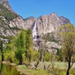
The Kaweah River emanates from the High Sierra, soaked by the heavy snow and rain of Sequoia and Kings Canyon National Parks, flowing down toward the valley below. The Kaweah spins a wild and wonderful alternative story to the fields of almond trees and cotton and the drilling derricks that characterize sections of the San Joaquin landscape.
This is a land shaped by floods as much as drought and deserves an extended visit to take in the history and beauty of these small towns and open fields, where the steep flow of the Kaweah tumbles down the slopes into the alluvial plan that once was an inland delta leading to Tulare Lake.
STORY: The Edge of Yosemite Comes Alive in Tuolumne County

Tulare Lake, the Great Flood, and the Yokuts Creation Story
The local Indigenous folks, the Wukchumni, a Yokuts Tribe, have a creation story involving a great flood. This may serve as a simulacrum of the 2023 floods and could become an issue again when the massive atmospheric rivers and their snowmelt flow downhill.
Tulare Lake had been considered a prehistoric-turned-ghost-lake that dried up due to agricultural-settler-intervention in the 1800s as well as continued drought. The recent flood submerged almost 100.000 acres of farmland. Once it was the largest body of fresh water west of the Mississippi River. The return of Tulare Lake revitalized local ecosystems, attracting ducks, egrets, and waterfowl, despite the cost to farmland. Now there’s a plan to permanently restore the lake.

The Tachi Yokuts call it Pa’ashi, and until the late 19th Century with no natural outlet within the valley, the lake was 100 miles long and over 30 miles wide. Because of its unique ecosystem, retired College of the Sequoias Biology/Ecology professor Rob Hansen called it “the Serengeti of California.”
Four rivers originally drained into the lake, Kings, Kaweah, Tule, and Kern. In the rush for all the new settlers and gold prospectors to control land, the lake was starved through diversions to irrigate the arid fields in the vicinity, which became farm homesteads.
Today large-scale industrial agricultural giants like J.G. Boswell, the “King of California” cotton magnate-turned tomato empire, and Stuart Resnick’s Wonderful Company’s pistachios and citrus, dominate the landscape. Maybe the land remembers and yearns to return to the once-lake-turned-dusty-ghost.

“Tulare Lake was a patchwork of habitats running that ecological gambit from alkaline desert to lush riparian forest. The western portions lay in the rain shadow of coastal mountains, and moving further east, flatlands gave way to short grasslands, and these grasslands in turn transition to salt marshes that thrive along the lake’s tall grasslands.” — Rob Hansen, Tulare Lake Reflections

The Tachi proposal would acquire several private and public lands, including 1,100 acres from J.G. Boswell, to be permanently flooded to protect the rest of the region from another catastrophic inundation. It would also provide a local water reservoir storage/groundwater-recharge fount close to the California Aqueduct. By restoring the impenetrable tule wetland ecology long lost since the lake was drained, Pacific flyaway bird and vital aquatic life, clams, mussels, and western pond turtles, could once again thrive in the Valley.
Dwight Miller from the Center of Culture, Art, and History in the town of Exeter (CACHE), asserted that with the value of water in this landscape, farming may become less valuable than these types of Tulare Lake restoration plans. This could ensure ensuing generations of residents and farmers can build resilience against our heating climate and whiplash drought-flood-cycle.
Land-Back for the Tule Indian Tribe

Speaking of San Joaquin Valley tribal conservation movements, the Tule Indian Tribe had 17,000 acres of ancestral lands returned to them in 2025. Private funders and the State of California came together with the tribe to make this happen. Located adjacent to Giant Sequoia National Monument and southeast of Visalia, the Indigenous-land-back project discontinues the cattle ranching abuses and embarks upon a host of conservation projects, including the re-introduction of the Tule elk. The Deer Creek watershed will be protected, an accompaniment to the ongoing re-introduction of beaver on the south fork of the Tule River, as well as re-invigorating important California condor habitat.
While National Parks and Monuments serve as vital places for endangered wildlife and groves of giant Sequoias to thrive, these smaller, less-well-visited ecosystem restoration and conservation projects give space for clean water to flow and wildlife to roam.

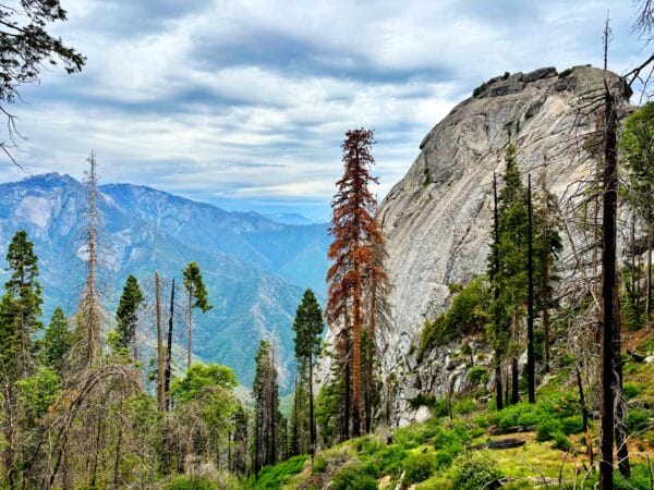
Giant Sequoias, River-Caves, and the Fire-Adapted Ecosystem
We toured through the underground world of Crystal Cave, delicate rimstone dams and marble columns formed by Yucca Creek, within Sequoia National Park with Daniel Huecker, from Sequoia Parks Conservancy. While many thousands of people visit the cave over a year, Daniel assured us that the Conservancy and Park Service keep everyone to a minimal impact in the darkened passages. The bubbling Yucca Creek dissolved away the marble over time and then joins Cascade Creek, which later reaches the North Fork of the Kaweah. When it comes to water flow, everything is connected.

“The Sierra should be called, not the Nevada or Snowy Range, but the Range of Light. And after ten years of wandering and wondering in the heart of it, rejoicing in its glorious floods of light, the white beams of the morning streaming through the passes, the noonday radiance on the crystal rocks, the flush of alpenglow, and the irised spray of countless waterfalls, it still seems above all others the range of light, the most divinely beautiful of all the mountain chains I have ever seen.” – John Muir, My First Summer in the Sierra, 1911

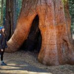
Fire has made a significant mark on the Giant Sequoias (Sequoiadendron giganteum), the massive thousands-year-old sentinels. Wildfires seem to consume sections of the high country every year in our present times of anthropogenic-caused hotter heatwaves and prolonged drought.
While the thick, fibrous outer bark has protected the sequoias, surreptitious wildfires have weakened this defense: fire-scarred monarch trees with blackened crowns can’t survive multiple burns. And burn-suppressing Euro-American managers failed to learn traditional fire application lessons from the Indigenous residents, so high-intensity blazes have become regular.

I visited Giant Sequoia National Monument In November with two determined forest scientists, Maya Khosla and Craig Swolgaard. They work with Dr. Chad Hansen who I have collaborated with in the past on post-fire Yosemite plans to “salvage” log rather than allow natural regeneration after high-intensity burns.
While walking the Trail of 100 Giants, Maya taught us a crash-course in Forest Fire Ecology that the U.S. Forest Service responsible for their management seems to misunderstand. Sequoia groves and their mixed-conifer neighbors can and will regrow and thrive with abandon, without bulldozers and chainsaws, and especially minus the mass salvage logging. Those burned snags become important black-backed woodpecker habitat, feeding on wood-boring beetles, succeeded by small animals and swallows, swifts, and bats.

Redefining Wilderness in the Sierra Nevada
Consider that fire can be applied through active stewardship, including allowing lightning-sparked fires in wilderness areas far from roads or people. This is something many Indigenous communities understand well. Unfortunately, the Forest Service seems to have gotten this balance wrong, with their policy of suppression of natural ignitions. They prefer “managed” fires across wildernesses, places humans and their drones and bulldozers should stay away from.
The extreme Sierra and Sequoia Prescribed Burn Project can include helicopters and drones dropping incendiary devices and using chainsaws for pre-fire tree cutting. They are looking toward thinning and burning 2.4 million acres of High Sierra national forest. Much of this is slated for roadless areas. This plan would displace and kill threatened or endangered wildlife like the spotted owl, wolverine, and Pacific fisher.
Furthermore, the Trump Administration proposal to rescind the 2001 Roadless Area Conservation Rule would further malign these important expanses. We need to let our wilderness areas protect and manage themselves laid out in the 1964 Wilderness Act, which made these types of militaristic invasions illegal.

“A science of land health needs a base datum of normality, a picture of how healthy land maintains itself as an organism…the most perfect norm is wilderness.” — Aldo Leoplold

Communing with the Valley-Mountain-River Wild
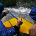
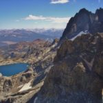
Sequoia’s ecosystem health, peaks soaring to 12,000 feet, woodlands, meadows, and granite domes, with white-water rafting on the Kaweah and streamside camping in King’s Canyon, depends upon the atmospheric rivers and snowbanks to keep the system flowing. And the fact that the valley is planning for water resilience in a world of changing precipitation patterns and brutal heatwaves and drought becomes an imperative symbiosis.
As you drive from the valley floor into the mountains, from agricultural fields to ancient forests, from human-engineered water systems to natural watersheds, you traverse more than elevation zones. You’re moving through interconnected systems facing massive change.
May the Valley communities invest in restoration of their natural tule wetland abundance, invest in ecological water storage and groundwater recharge. And may the managers of the future giant groves of Sequoias and roadless wildernesses have faith in allowing mixed-intensity fires to invigorate that time-tested lifecycle, without the ‘dozers, chainsaws, and drones. And may us visitors come to the Valley-Mountains with a hunger to learn about these quaint art-mural-covered towns like Exeter, Indigenous traditional ecological knowledge of the Yokuts People, and seeking regenerative agricultural models to confront the industrial farming legacies. Natural wonders abound!
Trip with the Outdoor Writers Association of California (OWAC), sponsored by Visit Visalia. Thanks for tours by Daniel Huecker (Sequoia Parks Conservancy) and John Oneto (farmer and co-owner of Naturally Nuts). Much appreciation to the Wyndham Hotel Visalia for hosting the conference.


Pingback: The Edge of Yosemite Comes Alive in Tuolumne County - WilderUtopia
Pingback: Green Mission News – May 2026 – Green Mission News